| Historical Source |
| W |
|
Wright's Survey Map of Chicago, 1834
|
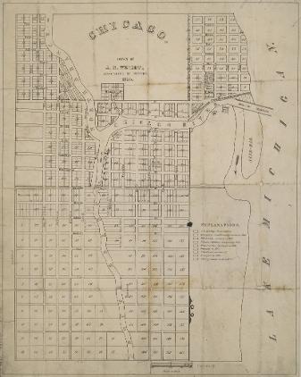
J. S. Wright's map of 1834 shows the city's familiar grid pattern, the cut in the sandbar that gave the Chicago River more direct access to Lake Michigan, Fort Dearborn just south and west of the cut (near the current Michigan Avenue Bridge), the North Side property of early Chicago settler John Kinzie, the "Public Square" that became the site for a succession of city halls (including the present one), and South Water Street (now Wacker Drive).
The Electronic Encyclopedia of Chicago © 2005 Chicago Historical Society.
The Encyclopedia of Chicago © 2004 The Newberry Library. All Rights Reserved. Portions are copyrighted by other institutions and individuals. Additional information on copyright and permissions.
The Encyclopedia of Chicago © 2004 The Newberry Library. All Rights Reserved. Portions are copyrighted by other institutions and individuals. Additional information on copyright and permissions.