| Historical Source |
| A |
|
Aerial View of Main Branch of Chicago River, 1951
|
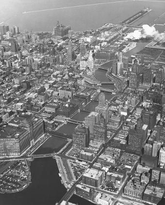
The curve of the river dictates the form of Wacker Drive, the only street in the city that has addresses with directionals for north, south, east, and west. In this photo looking east along the main branch of the Chicago River, Wacker Drive can be seen as it follows the south shore of the main branch before turning south at Wolf Point (in the lower left corner of the photo) to follow the east bank of the river's South Branch. The double-decked Wacker Drive, completed in 1926, initially extended west and south to Lake Street, where it became Market Street. In 1953, the City Council changed the name of Market Street to South Wacker Drive.
The Electronic Encyclopedia of Chicago © 2005 Chicago Historical Society.
The Encyclopedia of Chicago © 2004 The Newberry Library. All Rights Reserved. Portions are copyrighted by other institutions and individuals. Additional information on copyright and permissions.
The Encyclopedia of Chicago © 2004 The Newberry Library. All Rights Reserved. Portions are copyrighted by other institutions and individuals. Additional information on copyright and permissions.