| Historical Source |
| P |
|
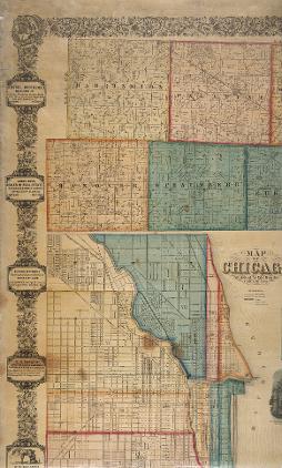
Plat Map of Cook County, 1861
|
|
|
|
This large, detailed map identifies title-holders of developed and undeveloped areas of Cook County outside Chicago in 1861. Sections that had been laid down by government surveyors and sold as single parcels subsequently had been divided into smaller lots for purchase. The boundaries of many of these smaller, subdivided holdings followed the familiar rectangular grid pattern, rather than rivers or other natural boundaries.
The Electronic Encyclopedia of Chicago © 2005 Chicago Historical Society.
The Encyclopedia of Chicago © 2004 The Newberry Library. All Rights Reserved. Portions are copyrighted by other institutions and individuals. Additional information on copyright and permissions.
The Encyclopedia of Chicago © 2004 The Newberry Library. All Rights Reserved. Portions are copyrighted by other institutions and individuals. Additional information on copyright and permissions.