| Entries |
| T |
|
Topography
|
|
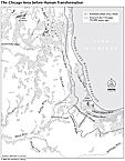
Chicago's flat topography is the result of its origin as a lake bottom. On at least three occasions between 14,500 and 4,000 years ago, glacial Lake Chicago, as this temporary enlargement of Lake Michigan was known, rose and fell. The balance was determined by the size of the glacier that blocked drainage to the north and the depth of the Des Plaines River outlet through the bedrock layers near Lemont. Glacial Lake Chicago was at its maximum extent about 12,500 years ago when it covered what is now the entire city of Chicago.
|
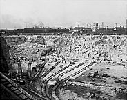
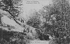
Like present-day beaches, these ancient features consist of almost pure sand. In contrast are the glacial moraines that formed at the margins of the stagnant or retreating ice sheets and which consist of unsorted boulders, sand, clay, and pebbles. Prominent among them is the morainic ridge known as Blue Island which was surrounded by the waters of glacial Lake Chicago. It extends from Dan Ryan Woods (87th and Western) nearly six miles south to the Calumet Sag Channel in Blue Island.
|
Still higher (and older) are the Tinley and Valparaiso morainic systems, whose outline also parallels that of Lake Michigan, but about 15–20 miles to the west. Rolling topography associated with the Valparaiso moraine occurs in a wide swath around the southern end of Lake Michigan and includes the hills of such communities as Barrington, Wheaton, and Monee. The Tinley moraine occupies a similar swath, about six miles closer to Lake Michigan, and includes Flossmoor, Western Springs, and Arlington Heights.
This entire complex of features—Lake Michigan, the beach ridges, and moraines—lies at a higher elevation than the Upper Illinois River valley. The city of Morris, where the Des Plaines and Kankakee Rivers join to form the Illinois, lies about 75 feet below the level of Lake Michigan. Crossing the drainage divide between the Des Plaines–Illinois–Mississippi system to the west and the Chicago River–Lake Michigan–St. Lawrence River system to the east thus involves “stepping up” in elevation even though the drainage divide itself is barely noticeable.
The Encyclopedia of Chicago © 2004 The Newberry Library. All Rights Reserved. Portions are copyrighted by other institutions and individuals. Additional information on copyright and permissions.