| MAPS : MAPS CREATED BY ENCYCLOPEDIA STAFF |
| L |
|
Land Subdivision and Urbanization on Chicago's Northwest Side
|
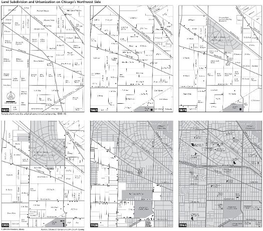
These six maps trace the development of the Norwood Park area through initial land sale, farming, suburban enclave, and urban neighborhood. The 1851 map identifies the first owners of land parcels shaped by the rectangular national land survey system and reveals the permanent imprint of the Native American era with the reserve created for Billy Caldwell, the Indian Boundary Line, and the diagonal roads based on Indian trails. In 1861 new farmsteads revealed landholdings turning into productive farms served by a new railroad line from Chicago, and a county poor farm appeared. By 1870 a curvilinear suburban subdivision had been laid out around the train station, the beginnings of a residential commuter suburb still surrounded by farms. The 1901 map shows denser subdivision and an enlarged cemetery but still much continuity in rural land ownership, though non-farm residences were beginning to accumulate along well-traveled roads. By 1928 the area was being inundated with gridded urban subdivisions as Norwood Park was pulled closer within the orbit of the central city and became an urban neighborhood. Some of the open space was preserved for golf links and a forest preserve. By 1963, the Kennedy Expressway cut through the community, which had become fully built up by then, its one golf club having succumbed to residential redevelopment. Together, the six maps show changes in transportation that bound Norwood Park ever closer to Chicago, as well as the evolution of community institutions in the context of land-use competition within the area.
The Electronic Encyclopedia of Chicago © 2005 Chicago Historical Society.
The Encyclopedia of Chicago © 2004 The Newberry Library. All Rights Reserved. Portions are copyrighted by other institutions and individuals. Additional information on copyright and permissions.
The Encyclopedia of Chicago © 2004 The Newberry Library. All Rights Reserved. Portions are copyrighted by other institutions and individuals. Additional information on copyright and permissions.