| MAPS : MAPS CREATED BY ENCYCLOPEDIA STAFF |
| E |
|
Economic Origins of Metropolitan Chicago Communities
|
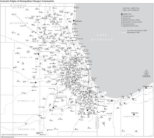
The classification of community types displayed on this map is based primarily upon entries in this encyclopedia. Identifications reflect the initial impetus for clustered settlement beyond agricultural use, effectively the initial step in the urbanization process. Note the relationship between history and geography. Eight old industrial satellite cities ring the metropolis at a distance of about 25 to 40 miles, while old agricultural trade centers stud the region as a whole. Canal towns line the Illinois & Michigan Canal heading out of Chicago to the southwest, while communities that started as railroad suburbs line the major commuter railroad corridors. Later automobile-era suburbs fill in many of the interstitial spaces. Industrial suburbs of varying age appear with greater frequency on the near west and south sides of the metropolitan area, while recreational towns are more abundant to the north and northwest.
The Electronic Encyclopedia of Chicago © 2005 Chicago Historical Society.
The Encyclopedia of Chicago © 2004 The Newberry Library. All Rights Reserved. Portions are copyrighted by other institutions and individuals. Additional information on copyright and permissions.
The Encyclopedia of Chicago © 2004 The Newberry Library. All Rights Reserved. Portions are copyrighted by other institutions and individuals. Additional information on copyright and permissions.