|
Gallery
|
| Governing Space |
| Incorporation |
| Annexation |
| Townships |
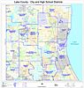
| School and Other Special Districts |
| Municipal Powers |
| Intergovernmental Relations |
| Federal Space |
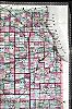
The Chicago metropolitan region as defined in this Encyclopedia extends over the border from Illinois into Indiana, and the state boundary is perhaps the region's only feature of governmental geography to have remained stable since Indiana became a state in 1816. Each state has created its own framework of counties, townships, municipalities, and school and other special districts, each layer of which has had its own territorial pattern. With changes in social geography, economic geography, and political culture, the geographies of local governance have also changed, although more slowly. The pattern of counties and townships was in place by the early 1850s, with relatively minor changes to the townships in later years. Counties cover the region as tiles, encompassing all points in the region. The region's counties in turn, empowered by the state, tiled the areas outside the city of Chicago with civil townships. While county and township governments provided services in rural areas, urban density created challenges that called for a different sort of local government. States have defined various structures of municipal governmentvillages, towns, and citieswith power over a defined territory, and have defined the means by which such governments may incorporate. Not all places within the metropolitan area have fallen inside the bounds of a municipal government, but as municipalities have multiplied and have grown by annexation, municipal governments have covered more of the area and have in many cases eclipsed township governments.
|
|
|
|
|
|
|
|

|
|
|
|
|
|
|
|
|
|
|
|
|
|
The Electronic Encyclopedia of Chicago © 2005 Chicago Historical Society.
The Encyclopedia of Chicago © 2004 The Newberry Library. All Rights Reserved. Portions are copyrighted by other institutions and individuals. Additional information on copyright and permissions. |