| Entries |
| I |
|
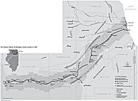
Illinois and Michigan Canal
|
|
Louis Jolliet first suggested the possibility of such a link in 1673 when he encountered the Chicago Portage. The idea was taken up in 1822, when Congress made an initial land grant to Illinois for constructing a canal. Justus Post and René Paul made the first survey of possible routes. In 1830 the canal commissioners platted Chicago and Ottawa in the vain hope of raising sufficient money by selling land from a second land grant. The commissioners and private speculators platted numerous towns in the 1830s and 1840s, including Lockport, Joliet, Channahon, and LaSalle, as well as other towns that did not survive.
Canal construction began in 1836, but a depression over the following seven years brought the state to the brink of bankruptcy. The canal was finally completed after a financial and administrative reorganization in 1845. Much of the work was done by Irish immigrants who lived and worked in transient work camps along the line of the canal. The project required the construction of 15 lift locks, five aqueducts, and four hydraulic power basins.
|
The I&M Canal was the first inland canal to begin to shift from mule-drawn towlines to steam-propelled boats after 1871. Navigation became increasingly difficult as the state stopped investing in the maintenance of the canal. By the late 1890s commercial traffic had greatly diminished, and by 1914 it had all but ceased.
After 1900 interest in the canal shifted to recreational use. Canal excursion boats served a number of amusement parks, such as Rock Run outside Joliet.
|
The Encyclopedia of Chicago © 2004 The Newberry Library. All Rights Reserved. Portions are copyrighted by other institutions and individuals. Additional information on copyright and permissions.