| Entries |
| T |
|
The Loop
|
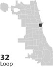 Community Area 32. The Loop is the popular name for the Chicago
business
district located south of the main stem of the
Chicago River.
The name apparently derives from the place where the strands powering cable cars turned around on a pulley in the center of the city. The concept was extended to the ring of elevated rail tracks for
rapid transit
lines connecting downtown with the neighborhoods. Completed in 1897, this loop created an integrated intracity
transportation
system that helped insure the dominance of Chicago's historic core in the development of the metropolis. All of Chicago's nineteenth-century railroad depots were located at the edges of the central business district, creating a circle of stations around the hub of the city.
Community Area 32. The Loop is the popular name for the Chicago
business
district located south of the main stem of the
Chicago River.
The name apparently derives from the place where the strands powering cable cars turned around on a pulley in the center of the city. The concept was extended to the ring of elevated rail tracks for
rapid transit
lines connecting downtown with the neighborhoods. Completed in 1897, this loop created an integrated intracity
transportation
system that helped insure the dominance of Chicago's historic core in the development of the metropolis. All of Chicago's nineteenth-century railroad depots were located at the edges of the central business district, creating a circle of stations around the hub of the city.
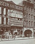
Jean Baptiste Point DuSable established a trading post on the north bank of the Chicago River in the late 1780s. Fort Dearborn followed on the opposite side in 1803–4. South Water Street, along the south bank, became a hub of activity in the 1830s, with Lake Street, a block to the south, soon picking up the character of a retail street. In the period of the walking city the Loop area accommodated all of the functions of the city near the main stem of the river.
|
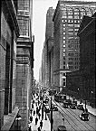
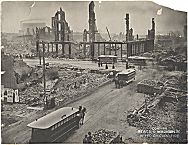
The Civil War brought rapid growth downtown encouraged by the use of streetcars, which first appeared along State Street in 1859. At the war's end Potter Palmer engineered the shift of retail commerce from Lake Street to State Street by erecting a splendid hotel, a large commercial emporium, and other mercantile buildings along State Street. This reorientation of the business district was well underway when the Fire of 1871 completely destroyed the central part of the city.
|
|
After 1950 the outward pull of suburban development in the new automobile metropolis reduced the importance of the Loop in the daily lives of many Chicagoans. It no longer functioned as a second neighborhood for numerous citizens and retail sales downtown accounted for a much smaller portion of the metropolitan total. An extension of the central business district northward along Michigan Avenue kept a luxury shopping district close by, and a return of residential buildings downtown brought back aspects of the old walking city. Cooperation between the city government led by Richard J. Daley and business leaders, supported by a steady flow of state and federal funds, produced a building boom of unprecedented scale to provide offices for corporations, banks, and governmental agencies, as well as hotel rooms for visitors, and expanded facilities for cultural and educational institutions.
| Loop (CA 32) | |||||
| Year |
Total
(and by category) |
Foreign Born | Native with foreign parentage | Males per 100 females | |
| 1930 | 7,851 | 28.2% | 30.3% | 394 | |
| 7,639 | White (97.3%) | ||||
| 98 | Negro (1.2%) | ||||
| 114 | Other (1.5%) | ||||
| 1960 | 4,337 | 7.1% | 13.8% | 502 | |
| 3,841 | White (88.6%) | ||||
| 449 | Negro (10.4%) | ||||
| 47 | Other races (1.1%) | ||||
| 1990 | 11,954 | 9.0% | — | 112 | |
| 8,924 | White (74.7%) | ||||
| 2,451 | Black (20.5%) | ||||
| 44 | American Indian (0.4%) | ||||
| 448 | Asian/Pacific Islander (3.7%) | ||||
| 78 | Other race (0.7%) | ||||
| 679 | Hispanic Origin* (5.7%) | ||||
| 2000 | 16,388 | 15.1% | — | 105 | |
| 10,744 | White alone (65.6%) | ||||
| 3,249 | Black or African American alone (19.8%) | ||||
| 46 | American Indian and Alaska Native alone (0.3%) | ||||
| 1,631 | Asian alone (10.0%) | ||||
| 16 | Native Hawaiian and Other Pacific Islander alone (0.1%) | ||||
| 293 | Some other race alone (1.8%) | ||||
| 409 | Two or more races (2.5%) | ||||
| 975 | Hispanic or Latino* (5.9%) | ||||
The Encyclopedia of Chicago © 2004 The Newberry Library. All Rights Reserved. Portions are copyrighted by other institutions and individuals. Additional information on copyright and permissions.