| Entries |
| S |
|
Subdivisions
|
From the city's beginnings, land was one of Chicago's most attractive commodities, and sales and speculation in real estate were among the earliest trades to flourish. Local citizens as well as East Coast and foreign investors rode the cycles of speculative booms and busts, winning and losing fortunes with each wave of trading activity.
|
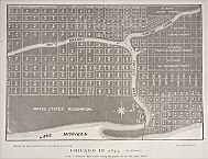
A large grant of land was given to the state of Illinois in 1822 to finance construction of the Illinois & Michigan Canal. A period of wild speculation ensued, setting the pattern for the future: each new transportation project stimulated a speculative frenzy and swelled the supply of subdivided acreage.
New transportation technology also encouraged subdivisions at increasing distances from the city core. Beginning in 1848, railroad connections led to new development at stations along their radial routes. Soon the horse-drawn omnibus and then the street railway fostered subdivision development along their routes. Subdivisions both north and south along Lake Michigan such as Lake Forest and Hyde Park, which began as summer retreats for the wealthy, increasingly evolved into commuter suburbs, as did outlying settlements to the west. By 1857, the subdivided area of Chicago embraced more than 24 square miles, and by the end of the Civil War Chicago's suburban belt extended more than 40 miles from the center.
Periodic depressions after the Civil War interrupted but did not stop development, which was spurred by the introduction of electric trolley service in the 1880s, the elevated rapid transit in the 1890s, and preparations for the 1893 World's Columbian Exposition. Distance from the center, proximity to industry, the provision of utility connections and other improvements, and the use of restrictions, building codes, and zoning contributed to the creation of subdivisions differentiated by class and race.
|
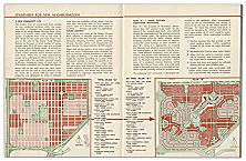
The survey grid dominates the subdivision landscape, but Chicagoans have also supported influential innovations in subdivision design. These range from Frederick Law Olmsted and Calvert Vaux's Riverside (1868) to the planned new town of Park Forest (1948), and include the ideas on paper submitted to the 1913 City Club model suburb competition.
The Encyclopedia of Chicago © 2004 The Newberry Library. All Rights Reserved. Portions are copyrighted by other institutions and individuals. Additional information on copyright and permissions.