| Entries |
| C |
|
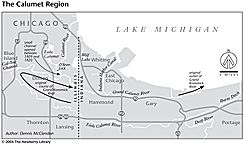
Calumet River System
|
The Calumet river system is a network of waterways, some human-made and others transformed by two centuries of human straightening, widening, dredging, channelizing, and damming, as well as by industrial pollution and landfilling of nearby marshes.
|
In 1823 a government engineer proposed placing the terminus of a canal between Lake Michigan and the Illinois River at South Chicago, but this plan for the Illinois & Michigan Canal was turned down in favor of a Chicago River terminus. The Calumet watershed remained flat and marshy and its waterways unnavigable. Only when downtown Chicago began to fill up and expanding heavy industry found itself short on space did developers and industrialists turn to the Calumet area, where they could still enjoy proximity to Chicago's transportation, markets, labor force, and business services.
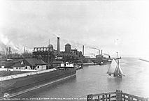
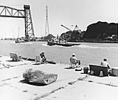
Industrial development became possible in 1869, when Congress appropriated money for a harbor at South Chicago. In the 1890s, the Calumet River was straightened and dredged. Industry began moving into the area in the 1870s, and by the early twentieth century the Pullman Company, the South Works of U.S. Steel, and other industries had been established in southeast Chicago and Hammond. To accommodate industry, the channel of the Grand Calumet was moved and straightened. The Indiana Harbor Canal connecting the Grand Calumet with Lake Michigan at East Chicago was completed in 1906, and industries moved to its banks. Burns Ditch, completed in 1926, connected the Little Calumet with Lake Michigan in Porter County, draining thousands of acres of marsh and facilitating development. Parts of the Grand Calumet and Little Calumet drained into the lake at these new outlets, depending on rainfall and lake levels. This harbor complex became the most important on the Great Lakes. With steel mills, oil refineries, chemical plants, packinghouses, and other industries, the Calumet system became the industrial center of the Chicago region. Since the model town of Pullman was built near its western shore in the early 1880s, Lake Calumet has been drastically altered. Vast areas of it have been filled in with refuse and converted to use as parkland and docks, while extensive dredging has deepened other parts to accommodate shipping.
|
|
The Encyclopedia of Chicago © 2004 The Newberry Library. All Rights Reserved. Portions are copyrighted by other institutions and individuals. Additional information on copyright and permissions.