| The Plan of Chicago |
| Chicago in 1909 |
| Planning Before the Plan |
| Antecedents and Inspirations |
| The City the Planners Saw |
| The Plan of Chicago |
| The Plan Comes Together |
| Creating the Plan |
| Reading the Plan |
| A Living Document |
| Promotion |
| Implementation |
| Heritage |

Plan of Chicago, Plate CXXI

This Guerin drawing is titled "Proposed Twelfth Street Boulevard at its Intersections with Michigan Avenue and Ashland Avenue." The view is toward the southwest. Visible east of the Chicago River on Twelfth Street (later Roosevelt Road) are the railroad terminals that the Plan proposed should be built in this location but never were. In the drawing, Twelfth Street west of the river is also a more elegant boulevard than it would become, complete with a landscaped central divider.
Twelfth and Jefferson Streets, 1906
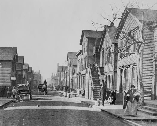
At the time of the Plan, Twelfth Street west of the river was a narrow passageway through a crowded neighborhood of recent immigrants.
View West along Roosevelt Road at Jefferson Street, 2004
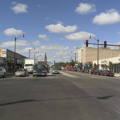
Roosevelt Road west of the Chicago River was substantially widened, and it has long been an active commercial street, though never the landscaped boulevard depicted by Guerin.
The Encyclopedia of Chicago © 2004 The Newberry Library. All Rights Reserved. Portions are copyrighted by other institutions and individuals. Additional information on copyright and permissions.