| The Plan of Chicago |
| Chicago in 1909 |
| Planning Before the Plan |
| Antecedents and Inspirations |
| The City the Planners Saw |
| The Plan of Chicago |
| The Plan Comes Together |
| Creating the Plan |
| Reading the Plan |
| A Living Document |
| Promotion |
| Implementation |
| Heritage |

Plan of Chicago, Plate CXXIV

Fernand Janin's "Plan of Grant Park and the Harbor, Showing Proposed Arrangement." This drawing of the proposed park features a nearly symmetrical placement of new buildings and landscaping. As the planners proposed, Janin centers the Field Museum at the eastern end of the east-west Congress Street axis, and he offers an appealing view of the downtown lakefront as a harbor for passenger steamers and pleasure craft. Curiously, Janin's drawing includes some structures not in other Plan drawings and descriptions, and it leaves out the Art Institute of Chicago, which had been in Grant Park for over fifteen years.
Grant Park Before Improvement
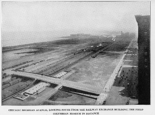
This view of the park was taken from the southeast corner of the Railway Exchange Building, a few yards from the rooftop studio where the Plan was created. This image was taken in 1920 or shortly after, since the new Field Museum, which formally opened in 1921, can be seen in the distance, but otherwise the park and surrounding areas are still largely unimproved.
Grant Park, 2004
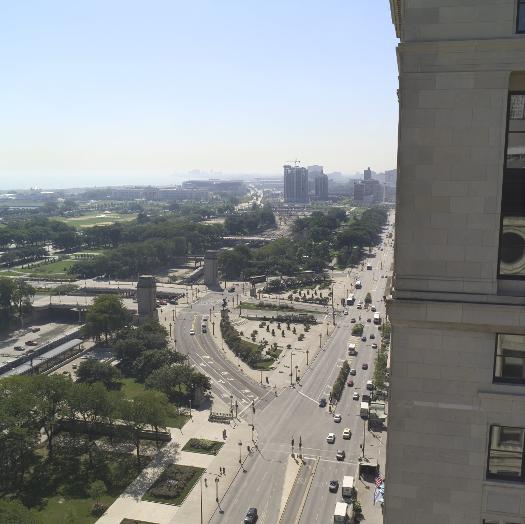
This view of Grant Park from the southeast corner of the Santa Fe (previously the Railway Exchange) Building was taken in September of 2004. Grant Park has been fully landscaped, and the Illinois Central tracks are much less visible than they were through much of the twentieth century. Note also the elaborate Congress Street entrance to the park.
The Encyclopedia of Chicago © 2004 The Newberry Library. All Rights Reserved. Portions are copyrighted by other institutions and individuals. Additional information on copyright and permissions.