| The Plan of Chicago |
| Chicago in 1909 |
| Planning Before the Plan |
| Antecedents and Inspirations |
| The City the Planners Saw |
| The Plan of Chicago |
| The Plan Comes Together |
| Creating the Plan |
| Reading the Plan |
| A Living Document |
| Promotion |
| Implementation |
| Heritage |

Plan of Chicago, Plate CXXVII

|
In the Plan, Jules Guerin's drawing is titled "Bird's-Eye View at Night of Grant Park, the Facade of the City, the Proposed Harbor, and the Lagoons of the Proposed Park on the South Shore." The view is southwest, with Grant Park on the right. What would become Northerly Island is here the northernmost reach of a stretch of manmade land that flanks the eastern edge of a continuous lagoon extending all the way southward to Jackson Park.
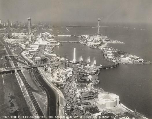
Northerly Island and Lagoon, 1933
|
The vantage in this bird's-eye view of the Century of Progress International Exposition, is looking north. While the Plan's proposal for a continuous lagoon along the South Side lakefront has been abandoned, Northerly Island, on the right, forms a small lagoon to its west. At the north end of the fairgrounds, one can see (moving from left to right), Soldier Field, the Field Museum (just beyond Soldier Field), the Shedd Aquarium, and (largely obscured by a Century of Progress tower) the Adler Planetarium.
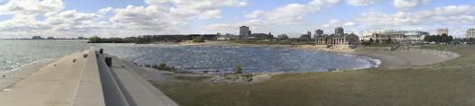
Panoramic View of Northerly Island, 2004
|
The viewpoint here is looking south from the Adler Planetarium. Meigs Field, which occupied Northerly Island for some fifty-five years, was shut down by the city of Chicago in 2003.
The Encyclopedia of Chicago © 2004 The Newberry Library. All Rights Reserved. Portions are copyrighted by other institutions and individuals. Additional information on copyright and permissions.