|
The Plan of Chicago
|
| Chicago in 1909 |
| Planning Before the Plan |
| Antecedents and Inspirations |
| The City the Planners Saw |
| The Plan of Chicago |
| The Plan Comes Together |
| Creating the Plan |
| Reading the Plan |
| A Living Document |
| Promotion |
| Implementation |
| Heritage |

Three of the illustrations in the Plan are based on drawings by Bennett, and one on a watercolor by Burnham, who also probably took some of the photographs that were used.
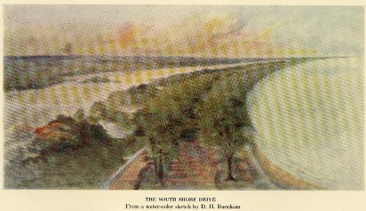
This watercolor, reproduced in Charles Moore's biography of Burnham, was likely painted in 1896, when Burnham was first thinking about a lakeshore parkway. It is the basis of plate L(a) in the Plan .
See also: Burnham Plan; Planning Chicago; Streets and Highways; Plan of Chicago (Digital Essay)
Winter View of Grant Park and the Proposed Harbor, Looking East

One of the three Plan illustrations by Bennett, this image appears above the title of Chapter IV. His drawings of Greece and Sicily appear in Chapter II.
Guerin, View of the Proposed Development in the Center of the City

This double-page drawing by Guerin from Chapter VII of the Plan appears to be based on the sketch of the same view by Bennett.
The Encyclopedia of Chicago © 2004 The Newberry Library. All Rights Reserved. Portions are copyrighted by other institutions and individuals. Additional information on copyright and permissions.