| Entries |
| C |
|
Cook County
|
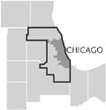 When Cook County was organized in 1831 with approximately 100 residents in 2,464 square miles, it encompassed much of what is today
Lake,
DuPage,
Will,
McHenry,
and Cookcounties. Because of population growth in northeastern Illinois in the 1830s, Cook County lost over half its territory, but continued to increase in population. By 1839, it comprised 954 square miles and followed its current irregular boundaries. It had expanded to a population of over four thousand.
When Cook County was organized in 1831 with approximately 100 residents in 2,464 square miles, it encompassed much of what is today
Lake,
DuPage,
Will,
McHenry,
and Cookcounties. Because of population growth in northeastern Illinois in the 1830s, Cook County lost over half its territory, but continued to increase in population. By 1839, it comprised 954 square miles and followed its current irregular boundaries. It had expanded to a population of over four thousand.
Although Daniel Pope Cook is the namesake of the county, there is no evidence that he ever visited the area. Cook served as the first Illinois attorney general and the second U.S. congressman from Illinois.
|
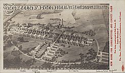
During the 1830s and 1840s, farmers purchased most of the available land in the county and began raising crops and livestock. Without railroads, some farmers hauled their harvest to Chicago, but others went to closer, smaller settlements. By 1840, Wheeling, Gross Point (now Wilmette ), Lyons, Summit, Brighton, Willow Springs, Calumet, Blue Island, and Thornton were thriving settlements. Most were agricultural centers, serving the farmers in their vicinity with small stores, churches, and schools.
|
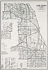
Between 1860 and 1890, the area of contiguous urban settlement grew substantially. By 1870, the Cook County Board was an unwieldy group of more than 50 town supervisors. Although over 85 percent of the population of the county resided within the city of Chicago, fewer than half of the board representatives were from the city. To remedy this problem, the state changed the organization of the board. The new 15-member board had 10 representatives elected from Chicago. After the 1889 annexation, which shifted more than 225,000 county residents to within the city and expanded the city's physical size from 43 to 169 square miles, over 90 percent of the county's population lived within the city.
The railroad (and increasingly street railways ) allowed Chicagoans to live and work in noncontiguous suburban areas. While farming in Cook County did not disappear, outlying growth by 1900 was decidedly suburban. The initial development and extension of the Elevated fostered the rise of population centers at Oak Park, Evanston, Uptown, and Hyde Park.
Many of the farms on Chicago's Far Northwest and Southwest Sides disappeared in the face of the speculative building boom of the 1920s. Industrial and residential developers began to work on suburban farmland convenient to bus, truck, and automobile traffic. By 1940, the proportion of the county's population living within Chicago had dropped to 83 percent.
|
| Cook County, IL | |||||
| Year |
Total
(and by category) |
Foreign Born | Native with foreign parentage | Males per 100 females | |
| 1840 | 10,201 | — | — | 142 | |
| 10,146 | Free white (99.5%) | ||||
| 55 | Free colored (0.5%) | ||||
| 1870 | 349,966 | 47.7 | 79.8 | 106 | |
| 346,102 | White (98.9%) | ||||
| 3,858 | Colored (1.1%) | ||||
| 6 | Indian (0.0%) | ||||
| 1900 | 1,838,735 | 34.0 | 42.6 | 103 | |
| 1,805,561 | White (98.2%) | ||||
| 31,838 | Negro (1.7%) | ||||
| 1,253 | Chinese (0.1%) | ||||
| 74 | Japanese (0.0%) | ||||
| 9 | Indian (0.0%) | ||||
| 1930 | 3,982,123 | 24.0 | 39.0 | 102 | |
| 3,708,281 | White (93.1%) | ||||
| 246,992 | Negro (6.2%) | ||||
| 275 | Indian (0.0%) | ||||
| 2,875 | Chinese (0.1%) | ||||
| 517 | Japanese (0.0%) | ||||
| 21,087 | Mexican (0.5%) | ||||
| 2,096 | Other (0.1%) | ||||
| 1960 | 5,129,725 | 10.6 | 23.6 | 95 | |
| 4,240,873 | White (82.7%) | ||||
| 861,146 | Negro (16.8%) | ||||
| 227,706 | Other races (4.4%) | ||||
| 1990 | 5,105,067 | 14.1% | — | 93 | |
| 3,208,115 | White (62.8%) | ||||
| 1,314,859 | Black (25.8%) | ||||
| 10,387 | American Indian (0.2%) | ||||
| 188,447 | Asian/Pacific Islander (3.7%) | ||||
| 383,259 | Other race (7.5%) | ||||
| 677,949 | Hispanic Origin* (13.3%) | ||||
| 2000 | 5,376,741 | 19.8% | — | 94 | |
| 3,025,760 | White alone (56.3%) | ||||
| 1,405,361 | Black or African American alone (26.1%) | ||||
| 15,496 | American Indian and Alaska Native alone (0.3%) | ||||
| 260,170 | Asian alone (4.8%) | ||||
| 2,561 | Native Hawaiian and Other Pacific Islander alone (0.0%) | ||||
| 531,170 | Some other race alone (9.9%) | ||||
| 136,223 | Two or more races (2.5%) | ||||
| 1,071,740 | Hispanic or Latino* (19.9%) | ||||
The Encyclopedia of Chicago © 2004 The Newberry Library. All Rights Reserved. Portions are copyrighted by other institutions and individuals. Additional information on copyright and permissions.