| Entries |
| D |
|
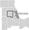
DuPage County
|
 Taking its name from the
DuPage River,
DuPage was established as a separate county from part of
Cook County
in 1839, with
Naperville
as the county seat. In 1850, DuPage County was organized into nine
townships,
through the efforts of state legislator Warren Wheaton (1849–1851). An 1857 attempt to relocate the county seat to
Wheaton
because of its more central location was defeated, but 10 years later the referendum succeeded in a close election. Naperville resisted turning over the county records, which resulted in a midnight raid by a contingent of
Civil War
veterans from Wheaton and Danby (now
Glen Ellyn
).
Taking its name from the
DuPage River,
DuPage was established as a separate county from part of
Cook County
in 1839, with
Naperville
as the county seat. In 1850, DuPage County was organized into nine
townships,
through the efforts of state legislator Warren Wheaton (1849–1851). An 1857 attempt to relocate the county seat to
Wheaton
because of its more central location was defeated, but 10 years later the referendum succeeded in a close election. Naperville resisted turning over the county records, which resulted in a midnight raid by a contingent of
Civil War
veterans from Wheaton and Danby (now
Glen Ellyn
).
Throughout its history, DuPage County's growth and development have been linked to Chicago and to transportation routes in northern Illinois. When American settlers began arriving in the 1830s, the area that would become DuPage County was already crisscrossed by Indian trails. By 1800 the Potawatomi Indians had established four major villages along local rivers. In the 1830s stage routes radiating out of Chicago were established, with way stations in the area of the DuPage River. The first Euro-American settlers in the area were Bailey and Clarissa Hobson and their five children, who came from Orange County, Indiana, by 1832. Hobson built a gristmill on the West Branch of the DuPage River, near present-day Hobson Road, in Naperville. After the 1833 Treaty of Chicago forced the Indians to move west of the Mississippi River, white settlement accelerated. During the 1830s and 1840s, newcomers first claimed land along the branches of the DuPage River and then filled in across the prairies.
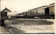
As Chicago became a central commercial point for the resources of a wide region, vital transportation routes passed through the area in transit to and from Chicago. In 1836 construction began on the Illinois & Michigan Canal, which in 1848 linked Lake Michigan to the Illinois River. Many Irish immigrants came to work on the I&M Canal and later settled in DuPage County. In the 1840s and '50s plank roads were built, established as private toll roads. The most significant development in transportation was the construction of railroads, beginning in 1848 with the Galena & Chicago Union Railroad. Six railroads and an interurban line would enter DuPage by the early 1900s. Irish, English, Germans, Italians, Mexicans, and African Americans came to work on these rail lines and stayed to live in DuPage County.
|
|
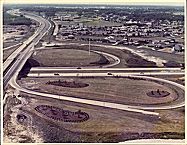
This improved transportation network helped to attract scientific and business developments. In 1947 the Atomic Energy Commission acquired a tract of 3,667 acres in DuPage County as a site for Argonne National Laboratory. Fermi National Accelerator Laboratory, the world's most powerful particle accelerator, was established on 6,800 acres (80 percent in DuPage County) and began operating in 1973. In 1958 Oak Brook, a planned community divided into residential, commercial, industrial, and recreational zones, was incorporated. Chosen for its strategic location near the intersections of I-88, I-294, and Route 83 (the main north-south road at the time) and proximity to O'Hare Airport, Oak Brook contributed to the perception of and growth of DuPage County as a center for business. By the 1980s DuPage touted its Research and Development Corridor along the East-West Tollway as a research and commercial center.
By 2000 more people were commuting into DuPage County for work (256,617) than were commuting out (191,439). The number of DuPage residents who stayed within the county for their work (277,934) had increased, a trend that has continued since 1970.
By 1995, only 5 percent of DuPage's land was identified for agricultural use. By 2000 the county's population had surpassed 900,000. Naperville, now DuPage County's most populous community, has developed into an “edge city.”
| DuPage County, IL | |||||
| Year |
Total
(and by category) |
Foreign Born | Native with foreign parentage | Males per 100 females | |
| 1840 | 3,535 | — | — | 123 | |
| 3,531 | Free white (99.9%) | ||||
| 4 | Free colored (0.1%) | ||||
| 1870 | 16,685 | 31.2% | 50.4% | 111 | |
| 16,652 | White (99.8%) | ||||
| 33 | Colored (0.2%) | ||||
| 1900 | 28,196 | 23.3% | 40.3% | 105 | |
| 28,021 | White (99.4%) | ||||
| 165 | Negro (0.6%) | ||||
| 10 | Chinese (0.0%) | ||||
| 1930 | 91,998 | 12.8% | 31.7% | 101 | |
| 91,410 | White (99.4%) | ||||
| 319 | Negro (0.3%) | ||||
| 3 | Indian (0.0%) | ||||
| 14 | Chinese (0.0%) | ||||
| 8 | Japanese (0.0%) | ||||
| 230 | Mexican (0.3%) | ||||
| 14 | Other (0.0%) | ||||
| 1960 | 313,459 | 5.0% | 20.1% | 99 | |
| 312,200 | White (99.6%) | ||||
| 677 | Negro (0.2%) | ||||
| 582 | Other races (0.2%) | ||||
| 1990 | 781,666 | 9.1% | — | 97 | |
| 715,304 | White (91.5%) | ||||
| 15,354 | Black (2.0%) | ||||
| 1,015 | American Indian (0.1%) | ||||
| 39,841 | Asian/Pacific Islander (5.1%) | ||||
| 10,152 | Other race (1.3%) | ||||
| 32,795 | Hispanic Origin* (4.2%) | ||||
| 2000 | 904,161 | 15.3% | — | 97 | |
| 759,924 | White alone (84.0%) | ||||
| 27,600 | Black or African American alone (3.1%) | ||||
| 1,520 | American Indian and Alaska Native alone (0.2%) | ||||
| 71,252 | Asian alone (7.9%) | ||||
| 217 | Native Hawaiian and Other Pacific Islander alone (0.0%) | ||||
| 28,166 | Some other race alone (3.1%) | ||||
| 15,482 | Two or more races (1.7%) | ||||
| 81,366 | Hispanic or Latino* (9.0%) | ||||
The Encyclopedia of Chicago © 2004 The Newberry Library. All Rights Reserved. Portions are copyrighted by other institutions and individuals. Additional information on copyright and permissions.