|
Gallery
|
| The Grid |
| Origins of the Grid |
| The River Breaks the Grid |
| Rationalization of Streets |
| Embracing / Rejecting the Grid |
| Transportation and the Grid |
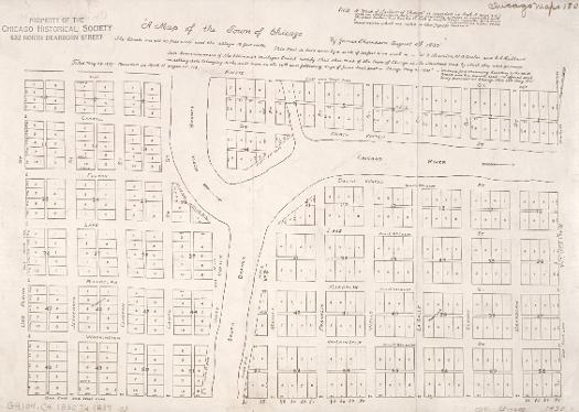
The rectangular grid of roads, farms, and city streets, so common to the Middle West and the region's largest metropolis, is largely a byproduct of financial considerations. Congress, eager to sell western lands to pay off the national debt, passed the Land Ordinance of 1785, an essential step in these sales. The ordinance provided that each territory would employ a geographer to survey the land, dividing it into townships six miles square, with the "townships, or fractional parts of townships, by numbers progressively from south to north, always beginning each range with the number one." Within the townships, surveyors were to mark off square mile sections numbered from one to thirty-six. The numbered grid thus created was the beginning of a system in which clear title could be quickly determinedideally designed for real estate sales. Chicago's grid fit neatly into the township pattern first established for the region by the 1785 Land Ordinance. Financial considerations again played a role in its implementation. Surveyor James Thompson laid out the town for the Canal Commissioners in preparation for the sale of lots to finance the proposed Illinois and Michigan Canal, with the first lots selling on September 4, 1830.
Surveying equipment of James Thompson, 1830
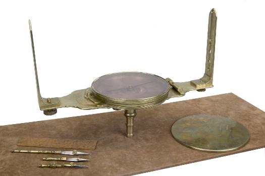
The Canal Commissioners hired James Thompson, a surveyor from Kaskaskia in downstate Randolph County, to create Chicago's first plat (or map showing proposed lots) in 1830. He laid out the town with straight streets uniformly 66 feet wide (the length of a surveyor's chain) with alleys 16 feet wide bisecting each block.
See also: Contested Spaces; Mapping Chicago; Multicentered Chicago; Planning Chicago; Streets and Highways
See also: Contested Spaces; Mapping Chicago; Multicentered Chicago; Planning Chicago; Street Naming
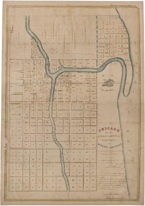
J. S. Wright, Survey Map of Chicago, 1834
Once this basic groundwork was laid, other surveyors followed, platting new sections to the same pattern. This 1834 map by John Stephen Wright combined the newly platted areas, showing the grid extending beyond Thompson's original boundaries. Wright arrived in Chicago in 1832 and became a prominent citizen and lifelong resident.
See also: Chicago River; Contested Spaces; Land Use; Mapping Chicago; Planning Chicago
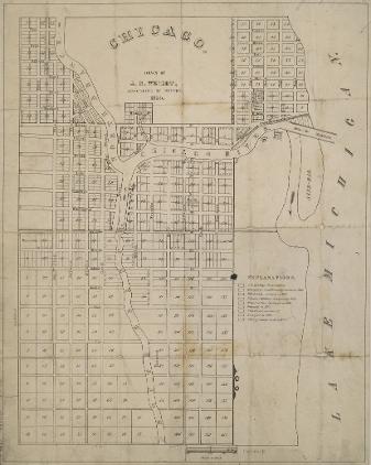
Chicago with the School Section and Wabansia and Kinzie's Addition, 1834
The Land Ordinance of 1785 stipulated that "there shall be reserved the lot No.16, of every township, for the maintenance of public schools within the township." The square-mile lots were usually known as sections, with smaller lots marked off for sale within them. Article 3 of the Northwest Ordinance of 1787 reinforced this support for education, in more grandiose but less practical language, stating that "religion, morality, and knowledge being necessary to good government and the happiness of mankind, schools and the means of education shall forever be encouraged." In this 1834 map, the "school section" is clearly shown. This square mile bounded by Madison, State, Twelfth (now Roosevelt Road), and Halsted Streets was sold on October 4, 1833, at an average cost of $60 per acre, a substantial increase from its 1830 value of $1.25 per acre.
See also: Government, City of Chicago; Mapping Chicago; Schools and Education; Townships
|
The Electronic Encyclopedia of Chicago © 2005 Chicago Historical Society.
The Encyclopedia of Chicago © 2004 The Newberry Library. All Rights Reserved. Portions are copyrighted by other institutions and individuals. Additional information on copyright and permissions. |