|
Chicagoans like to think of their home as “multiethnic,” or as “the city of neighborhoods.” Indeed, the celebration of neighborhood is one of the binding rituals of Chicago culture. The shelves of local bookstores are crammed with neighborhood guides of various sorts, and in the 1990s Mayor Richard M. Daley harnessed neighborhood consciousness to the marketing of
tourism,
officially defining certain well-known districts with banners, signs, and dramatic arches. When visitors come to the city one of the things they frequently ask to see is “Chicago's ethnic neighborhoods.”
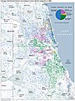
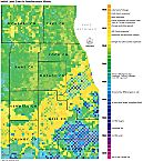
Residential Patterns, 2000 (Map)
|
Yet every big city in America is a city of neighborhoods—forged by migration,
work
patterns, race, religion, and other factors in addition to ethnic culture. Boston, San Francisco, and many other cities have their own rich patterns of colorful locales. What, if anything, makes Chicago's multicentered settlement pattern distinctive? Answering that question requires setting aside notions of neighborhood geography and diversity that became widespread in the mid-twentieth century but have been challenged by recent scholarship. It requires looking beyond the notion of “neighborhood” itself, as that term has been commonly and vaguely used, and thinking about Chicago's many spatial subcommunities as changing manifestations of history and human initiative. It requires looking deeper into Chicago's past, recognizing how the city's growth fits into the long history of national urbanization, and defining certain features of Chicago's development that were unusual.
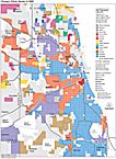
Chicago's Ethnic Mosaic in 2000 (Map)
|
For many observers in the twentieth century, the most obvious factor shaping Chicago's social geography seemed to be its role as a magnet for newcomers, with each new group establishing a highly visible presence in some piece of the city, and the city overall growing as a mosaic of cultural tiles, a collection of discrete, long-enduring, slowly changing ethnic/racial cells. Chicago was touted as the city with more
Poles
than any other except Warsaw or, in a darker view, as the most segregated city in America. Social scientists of the “Chicago School” promoted the idea that such well-defined subareas were “natural,” a product of physical and ecological processes governing urban growth.
In the past two decades, students of the city's history have noted limits to this vision of neighborhood development. With the important exception of the
African American
ghetto, Chicago's ethnic communities were never so well-defined or homogeneous as commonplace knowledge would have it. Even in Irish-dominated
Bridgeport
or the North Side's
Little Italy,
there were always people from other backgrounds. The world of Jurgis Rudkus, in Upton Sinclair's
The Jungle,
was centered in
Lithuanian
Catholic culture, but his neighbors were diverse, and his neighborhood was shaped as much by economic forces as by ethnicity. What's more, sociological assumptions about “natural areas” masked the dynamic qualities of ethnic and other neighborhoods—the enormous effort that Chicagoans invested in actively shaping their own communities: promoting them, sometimes defending them, and often moving them. Moreover, immigration and migration do not by themselves account for the pattern that has so vividly impressed visitors for more than a century: a great sprawling metropolis, including dozens of far-flung and constantly changing clusters, and scores of dispersed centers of employment and commerce. Chicago is more than an assembly of cultural chunks, its parts are ever changing, and its multicenteredness is rooted deep in the way it grew.
This is an essay about the variety of forces that have shaped not just the overall configuration of Chicago but the smaller spaces and communities in which Chicagoans have lived and worked. It is also about the variety of ways Chicagoans have imagined those subunits. Most residents, in the course of their daily lives, have had to deal with multiple roles and geographic elements, encountering the city as a complex and shifting array of focal points—places of
work,
worship, education, and amusement—rather than as a set of bounded cells. But there have been times and places where boundaries were important, and there has also been a history of “imagined communities” that resulted from the needs of government or information management or maybe the simple psychological need to simplify a hugely complicated
landscape.
All of these kinds of subcommunities have a history in every big city and a distinctive history in Chicago.
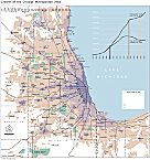
Growth of the Metropolitan Area (Map)
|
The flow of people into Chicago and the local communities they created were conditioned by three characteristics of the city's particular history. First, Chicago grew in a setting that is relatively—but not entirely—flat, and one that has been shaped and reshaped by numerous natural and artificial waterways. On the one hand, flatness made outward growth easy; on the other, it presented an endemic problem of managing
water:
supplying it, disposing of it, trying to make it go to some places and not to others. Second, Chicago's most spectacular growth spurt occurred when the national economy was driven by
railroads,
heavy industry, and European immigration. The city did not share in the long period of seaport growth that pushed East Coast cities and even inland ports like Cincinnati and St. Louis well on the way to big-city status. Moreover, Chicago's growth slowed when the centers of investment and production shifted westward in the second half of the twentieth century. Third, rapid growth offered extraordinary opportunities for both planning and conflict, and Chicago's landscape bears the marks of some of the most noble and some of the most invidious attempts at community building in American history.
Today's social geography is a product of the interaction of these three Chicago-specific characteristics, and today's Chicago bears the imprint of five prior phases of multicentered development. For convenience, they might be called periods of natural division, speculation and engineering, migrant clustering and industrial villages, cellular mapping, and elite community redevelopment. Each phase produced a new version of the multicentered city, occupying successively larger amounts of space. Furthermore, each phase was overlaid upon what came before, rather than neatly succeeding it, and the earliest still has influence on the twenty-first-century city along with the later four.
Natural Division, 1780–1830
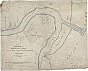
Plan for Mouth of Chicago River, 1830
|
The natural environment was paramount in shaping Chicago's earliest communities. The
Chicago River
and its two branches divided the site of initial settlement into three parts, which by the early nineteenth century would be known as the North, West, and South “Sides.” Native Americans who passed through and the European-descended people who settled permanently in the early nineteenth century built little clusters of dwellings in all three sectors of the area. A small group of civilians settled close to
Fort Dearborn
in what is now the northeast corner of the
Loop.
Fur traders,
tavern keepers, and mariners settled on the North and West Sides. Early Chicago contained several collections of huts, stores, shops, and warehouses strung out along the waterways. The British Kinzies on the North Side did not always get along with the mixed-blood LaFramboise clan down the South Branch, but they all built their houses close to the river that provided
transportation
for the community.
Yet water was a force for division as well as a focus of common activity. The river, sluggish and relatively narrow though it was, raised formidable obstacles to travel between the three segments of town. The first few decades of Chicago's history as a settlement are full of tales of ferries begun and abandoned,
bridges
erected and then washed away in spring
floods.
Even away from the river, the marshy, muddy quality of the site became a standing joke in early accounts of the town and a long-term problem for those trying to cultivate or build on the land. In these circumstances, glacial ridges and other scraps of high ground, stretching away from the village near the river's mouth, became the basis for roads and then linear farming settlements starting in the early 1830s. Thus, in addition to the early commercial center near the fort and the river's mouth, the high ground underlying the future Clark Street, Archer Avenue, and Cottage Grove Avenue provided the foundation for the first subcommunities in Chicago. Partly through historical accident, this first stage of development also inscribed lasting social distinctions on the landscape. The DuSable-Kinzie house, the largest and most opulent of Chicago's early dwellings, established a long tradition of affluent residences on the
Near North Side,
while the “Hardscrabble” settlement of traders and fur company workers on the South Branch represented the first of a long line of economically marginal but proud communities in that vicinity.
Speculation and Engineering, 1830–1880
James Thompson Surveying Tools, 1830
|
The hallmark of the second stage, from the early 1830s to the period of post-fire rebuilding in the 1870s, was an effort to reshape “natural” space, and the principal tools were political, economic, and technological. The initial events in this stage centered on the project to join the Mississippi and
Great Lakes
watersheds by means of a canal. That project, first envisioned in the seventeenth century, moved from long-term dream to near-term likelihood between the early 1820s and 1836. A series of surveys by state-appointed canal commissioners culminated in the platting of Chicago by James Thompson in 1830, a preparatory step to development. The federal government contributed by surveying northeastern Illinois into townships and sections, and granting more than 280,000 acres within the proposed canal zone in subsidy of that project. Long before there was much substantive evidence of either the canal or the town, the precision of surveyed lines and grids imposed a new matrix for the creation of speculative communities.
Initial Land Sales in NE Illinois (Map)
|
Speculation brought many new people to Chicago and created new roles for some old inhabitants. The most powerful actors in this new landscape of gridded space were of course those who had the means to deal in property, using either their own or other people's money. After the defeat of
Black Hawk's rebellion in 1832, and especially after the opening of a federal land office in 1835, Chicago received a flood of investors, land dealers, and potential settlers. Old-timers like the Kinzies and newcomers like William B. Ogden scrambled to profit by platting “additions” to the original city or seizing control of potentially valuable “water lots” miles from the existing settlement—even in locations as far away as Calumet and
Summit.
The formation of companies to build railroads expanded this pursuit, attracting attention to investment sites away from existing waterways. The timing of this speculative burst was full of implications for the city's future. When rail-based development came to older cities, even older interior cities such as Cincinnati or St. Louis, a large amount of capital and energy had already been invested in water-related facilities: levees, docks, shipyards, ropewalks, and the like. Remaking the fabric of the city to accommodate rail facilities involved either displacing or circumventing these established elements. Although Chicago also began its life as a water-oriented town, the process of fitting the city around a railroad skeleton began almost immediately and with few obstacles, either man-made or natural. In this sense, the city was “born modern”—and also born to sprawl.
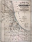
Railway Map, 1879
|
Even before canal construction started, the speculative process created a development engine that radically accelerated Chicago's decentralization and shaped the building of neighborhoods for decades into the future. Land speculation, of course, including speculation in urban land, was an old practice. Investors in many other American cities had grown rich from buying undeveloped land and waiting for it to appreciate. But for individuals like John Jacob Astor in New York or Nicholas Longworth in Cincinnati, city land was a long-term investment, as development moved slowly outward from old mercantile cores. In Chicago, by contrast, both speculation and development went into hyperdrive and stayed there for several decades, with only a few short interruptions. Investors sought short-term gains (as well as long), bought in many places at once, and did not wait for urban growth but pushed it in directions they wanted it to go. Profit depended on promotion, and thanks to elaborately embellished and colored maps, Chicago's imaginary landscape raced far in advance of reality. Thanks to entrepreneurial innovations, the real city quickly caught up with the maps. Many successful promoters plowed their profits back into town building, constructing wharves and warehouses, and joining together to dredge the river and clear the large sandbar from its mouth. To finance such development in a capital-starved region, they created land companies as conduits for eastern investors. Outsiders, especially from New York, poured capital into this city as they never had into Cincinnati or St. Louis, and the urban development process was thus from the beginning tied into larger regional and national interests. Local entrepreneurs and builders spurred the growth process further through rapid adoption of
innovations
like the
balloon frame
method of quickly erecting houses and commercial structures. Chicago's relatively flat landscape encouraged not only railroad but street railroad promoters, so that by 1880 it was not only the midcontinental hub of the rail system but also had local rail lines surpassed in mileage by only three of the older coastal metropolises. The whole process benefited, as older city growth had not, from federal largesse with land and federal policies of Indian removal. All of these refinements of the speculative process together were keys to Chicago's rapid sprawl to large size.
The result was that Chicago became not only the first of the nineteenth century's “instant cities” but also a city of instant neighborhoods. The engine of city building was also an engine of subcommunity development. Despite local rivalries, such as the one that led North Sider William B. Ogden to complain that “all the business is going over to the other side,” the overall effect was to create dozens of new settlements, of many kinds, from the 1830s through the 1860s. A few of these were residential promotions aimed at the prosperous elite, first near the city, as in the Near North Side island of gentility cultivated by the Ogdens, McCormicks, and Farwells; then farther out along the rail lines, as in Paul Cornell's development of
Hyde Park
or Henry
Austin's
investments in the suburb that bore his name. Other subcommunities were inadvertent creations near worksites along the river and the rails, such as the cluster near McCormick's reaper works or the dozens of later settlements around the stockyards. The overall effect was a sorting of space according to its developmental potential—for residential as well as commercial or industrial purposes—and this sorting produced new geographic reference points and categories. Especially in promoting middle- and upper-income residential areas, entrepreneurs worked hard to attach their own labels to the collective mental landscape, as in “Hyde Park,” “
Oak Park,
” and “
Ravenswood.
” In other cases, new names arose from common usage, as in “McCormickville,” “
Back of the Yards,
” and the numerous “patches” that designated clumps of worker-immigrant settlement near major employment districts.
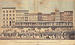
Street Raising on Lake Street, 1855
|
The arena of community-building activity was not at all the same thing as the built-up area or even the municipality. By the time of the
fire of 1871,
“Chicago” included not only the continuously developed area within about a mile of the river's mouth but also a wide array of residential suburbs, manufacturing communities,
quarry
villages, rail yard settlements, and market-gardening centers that merged gradually into the sprawling hinterland becoming rail-linked to the city. Historian William Cronon has shown how Chicago's
metropolitan growth
was symbiotic with a dramatic transformation of the environment for hundreds of miles around. In a more deliberate way, Chicagoans were also transforming the environment in and close to the city. Partly through necessity, partly through competitive zeal, Chicago's elite moved quickly to use new technology in refashioning the city, creating what Cronon calls “second nature” not only on the former prairies of Iowa but also in the former marshes of downtown. Beginning in the 1850s the city undertook a decades-long project of raising the grade of its streets to allow for the building of sewers. Under the guidance of engineer Ellis Chesbrough, Chicago became an internationally known experiment in water management. First in planning for drainage, and then in the 1860s in the cutting-edge
water supply
system that drove a
tunnel
under Lake Michigan and set up the Water Tower and Pumping Station on the North Side, the city authorities began a century-long process that would remake the hydrological profile of an area hundreds of square miles in extent.
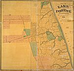
Map of Lake Forest, 1873
|
All the features of Chicago's early development—sudden and massive investment in a flat landscape, the codevelopment of city and rail lines, entrepreneurial zeal for both community building and huge technological systems—encouraged a multicentered pattern of growth. Chicago did not just spread outward from its core, it grew as a region, with many scattered centers developing simultaneously and in connection. Peripheral centers that were eventually annexed, such as
Andersonville
or Bridgeport, were initially developed in the speculative boom of the 1830s. Even outlying parts of the metropolitan complex—the North Shore suburbs, the canal towns to the southwest, the industrial centers near Calumet—are almost as old as the city itself.
Migrants and Community Building, 1840–1930
Developmental ventures attracted migrants who further diversified the city's geography. Alongside the highly visible engine of speculative development and engineering, there was another engine of ethnic and religious community formation. This second engine was less noticed than the first, but it would ultimately shape at least as much of the city's geography. And like the speculative engine it continued working well into the twentieth century, as the arena of city building and community making expanded further outward. Canal, river, and railroad development gave birth to working-class and immigrant settlements, but the residents quickly became community builders in their own right. Near the old Hardscrabble area on the South Branch, the mostly
Irish
laborers who dug the canal created the community called Bridgeport that would later attain legendary status in the city. Maritime workers on the canal, the river, and the lake fostered several raucous communities of
boardinghouses
and
saloons
on both sides of the South Branch near downtown, the most notorious of which was called “Conley's Patch.”
Germans
and Scandinavians who found work in the warehouses, shops, and
breweries
of the Near North Side established two zones of settlement, one between the North Branch and Wells Street, the other near the lake north of Chicago Avenue. In each of these cases, churches, taverns, clubs, and stores quickly followed, creating local cultures in which German,
Norwegian,
and Swedish mingled with English and compelling the city to hire interpreters for elections and at tax time. All of these developments were well underway by 1850, when the city was barely a decade old, and each of these communities in turn spawned more centers of ethnic life as these early immigrants sought work, land, and housing throughout the area. Other settlements—of
French,
Danish, Polish, German
Jewish,
and African American migrants—followed the same pattern in the 1840s and 1850s, so that by the
Civil War
Chicago was not only abloom with speculative additions, subdivisions, and suburbs but also displayed numerous overlapping ethnic clusters, each growing, each seeding its own centrifugal migration.
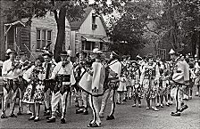
Polish Mountaineers' Parade, 1965
|
In the period between the
fire of 1871
and the
Great Depression,
Chicago grew from a regional center to the second largest city in the country, the most important rail hub in the country, the seat of many of the largest heavy industrial plants, and the destination for hundreds of thousands of European immigrants. The so-called new immigration of Southern, Eastern, and Central Europeans transformed the social geography of Chicago and most other great cities in the United States between 1880 and 1920, but it left different landscapes in different places. Chicago was a prime destination for the new immigrants, receiving more of them than any other urban center except Manhattan and Brooklyn. Toward the end of this period some observers began circulating the idea that Chicago had more Poles than any city except Warsaw. This claim was not quite true: metropolitan New York City, whose two million immigrants nearly equaled the total population of Chicago by 1910, had more citizens of Polish birth, as it did for most other immigrant groups. But Chicago did have more Poles than any one of New York's five boroughs, and it had larger communities of
Czechs,
Lithuanians,
Swedes,
Danes,
and
Luxembourgers
than any city in the country. What's more, the still-powerful cultural and institutional legacy of earlier immigrants—Irish, Germans, Scandinavians—made Chicago's blend of old and new hyphenated communities distinctive. New York City was the mecca of new immigrants; Milwaukee, a stronghold of old; Chicago had huge numbers of both.
The expansion of heavy industry and the flood of newcomers, combined with the building restrictions imposed after the fire, introduced new varieties of community building that affected the entire metropolitan area. On the edges of the old city, the super rich of the 1870s and 1880s promoted three new concentrations of mansions. They followed the leadership of Marshall Field on
Prairie Avenue,
Potter Palmer on Lake Shore Drive, and Samuel J. Walker along Ashland Avenue on the West Side. Meanwhile, prohibition of wooden frame buildings in the city's core encouraged new
construction
at the outskirts to house the flood of working-class newcomers. The result was a wide belt of small dwellings stretching from the
Old Town
area on the
Near North Side
through the
Near West Side
to the stockyards, Bridgeport, and the
Black Belt
south of the Loop. Within this belt were many clusters, old and new. Beyond, stretching out along the still-growing
street railway
on Lincoln, Milwaukee, Lake, Taylor, and Ogden, were more clusters of new settlement housing slightly more prosperous immigrants and their descendants. On the far South Side, industrial satellites appeared at
Pullman,
in the steel complex at the mouth of the
Calumet River,
and eventually in the huge manufacturing district stretching southeast into Indiana.
In a pattern that echoed earlier themes, speculative developers like Samuel Gross fueled the engine of geographic mobility by tailoring clusters of new homes for various pocketbooks. Subsequently the engine of cultural creativity enriched the new spaces with churches,
schools,
and other institutions that made them special places for this or that kind of people. By the late nineteenth century, observers could note the steeple-dotted skylines still evident today in older areas of ethnic settlement—steeples that serve as markers of the complex, overlapping, interpenetrating array of worshipping communities, the many languages and many architectures of devotion that Chicagoans created in this greatest surge of the city's growth. Especially for
Roman Catholics
(then and now a large segment of the population), but to some extent for Lutherans and others, the proliferation of
parishes
and congregations provided the most important framework of spatial orientation and loyalty in the city for a century after the fire.
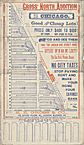
Samuel Gross's Subdivision
|
The same great surge of growth between fire and Depression produced another kind of community whose influence on the history of the city has been even stronger and more lasting than that of the immigrant clusters: the enormous and geographically isolated African American ghetto on the
South Side.
Popular accounts often trace the “Black Belt” to the
Great Migration
of the
World War I
era, but its history is far longer and more complicated. The three major areas of African American residence in Chicago, one in each division of the city, all trace their origins to tiny pre-fire settlements that once resembled those of many other migrants. They were primarily communities of manual workers who lived near rail yards, industrial centers, or wealthy neighborhoods where they could find employment as “hands” or as
domestic workers.
The South Side community was always the biggest, and like other migrant settlements it had its institutions, most notably Quinn Chapel AME church in the early years. Even before the Great Migration, the explosive growth of the late nineteenth century brought many thousands of black newcomers to Chicago and boosted the population of the South Side community to well over 40,000 by 1910. In the following two decades, at least another 70,000 arrived from the South, swelling and crowding the South Side black community just as white resistance to African Americans as neighbors made it the most ethnically homogeneous and isolated district in the history of Chicago.
Cellular Mapping, 1880–1940
The growing complexity of Chicago's social geography was accompanied by a growing series of efforts at simplified description. Even in the 1850s newspaper articles occasionally exaggerated and caricatured the homogeneity and cultural isolation of Irish and German communities. In 1881, veteran reporter F. B. Wilkie, his tongue lodged firmly in his cheek, published an apocalyptic vision of Chicago in 1906. His city of the future was divided into two huge sections, “Teutonia” on the north and “Hibernia” to the south, separated by a 60-foot east-west wall down the middle of Madison Street. In addition, one very small section of English speakers called “First Ward” occupied the area of the Loop. Other journalists, then and later, played up the activities of street
gangs
in defining and defending ethnic
turf,
and all of these writings worked to produce one of the lasting myths of Chicago's geography: the notion of stable, segregated, homogeneous, cellular ethnic neighborhoods.
Astute writers (including Wilkie) knew that the reality of Chicago's social geography was more complicated, and recent scholarship has emphasized that complexity. With the notable exception of the African American (and for a time the
Italian
) communities, Chicago's ethnic clusters were shaped more by the things that held them together than by lines that separated them. They were more centered than bounded. Locales were mixed, and most communities were dynamic—spreading, shrinking, hiving off pieces, changing with generations. To describe this dynamism, Robert Park, Ernest Burgess, and other scholars of the “
Chicago school” of sociology
popularized the idea of “
neighborhood succession,
” in which newer and poorer groups inherit neighborhoods left behind as more successful citizens seek better housing farther from the center.
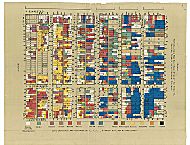
Hull House Map (Nationalities), 1895
|
Given all the evidence of complexity, the tendency toward cellular thinking becomes in itself a thing to be explained, and a piece of Chicago's distinctive version of multicenteredness. It was not just the journalists who contributed to the vision of an urban mosaic. Reformers, scholars, and officials played parts as well. Beginning in the 1890s,
philanthropists,
scholars, and
settlement house
workers focused renewed public attention on certain “new immigrant” districts within the sprawling belt of worker housing. Florence Kelley, Edith Abbott, and Sophonisba Breckinridge, in research that began at
Hull House
and continued using students from the
University of Chicago's School of
Social Service
Administration, produced a series of publications from 1895 to 1936 that graphically mapped conditions in many districts around the city. Although these researchers knew and appreciated the city's complexity, their color-coded maps and colorful descriptions of national cultures had the effect of attaching ethnic labels to the neatly delineated localities on their maps. The same sociologists who stressed “neighborhood succession” also helped to crystallize the notion of cells by promoting their idea that large cities are made up of “natural areas” separated by lasting physical boundaries. Robert Park, in what was probably a casual remark, produced a phrase that would take on a life of its own when he referred to a “mosaic of little worlds.” In one of academia's most dramatic contributions to the imagined landscape of any city, these scholars established the “
community areas
” that have served as tools of both valuable analysis and misleading simplification since the 1920s.
For some ordinary Chicagoans, other kinds of cellular thinking gained importance in this period, sometimes with tragic results. By the Depression, the South Side
Black Belt
was already the anomalous extreme case among Chicago's subcommunities. When a still larger migration came after
World War II,
a similar community sprawled across the West Side, and by the late twentieth century Chicago's more than a million African Americans were probably the most segregated large urban population in the nation's history. These two black communities were at once the nearest approximation of the mythic mosaic cell
and
the geographic element against which many other communities defined themselves. The parallel institutions of the African American community—businesses, churches, entertainment centers—made it a vital matrix of innovation not only for black Chicagoans but for African Americans nationwide.
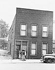
Letter and Restrictive Covenant, 1929
|
Yet the innovations fostered by the ghetto were double edged. As it grew, whites honed new methods of confinement. Some of these were political. A governing system based on 50 independent wards encouraged the building of the legendary
Democratic Party
organization assembled slowly since the time of Cermak and perfected by Mayor Richard J. Daley. Thousands of political workers and city employees were bonded to precinct and ward organizations run by powerful aldermen, who spread largesse strategically within their ward limits and carefully monitored voter turnout within those same categories at election time. Until the 1960s this was a system dominated by white males, in which black participation was limited to those few wards where African Americans were the majority. For the huge proportion of Chicago's white population that was Catholic, parish boundaries became defensive lines as the growing African American population sought housing in new areas. A parallel process occurred with school districts, and all three kinds of areas—wards, parishes, school districts—became battlegrounds in the racial struggles that played a central role in Chicago's geographic evolution from the 1940s through the 1960s. When Martin Luther King declared, in 1966, that he had never encountered Chicago's kind of
racism
in the South, he was commenting indirectly on the passions engendered by battles over particular and multiple kinds of urban territory.
Elite Community Redevelopment, 1940–2000
Properties Demolished for Ryan Expy.
|
Although Daniel Burnham, in the planning arena, and Anton Cermak, in the political, each had a broad vision of Chicago's future, it was the Depression crisis, more than any individual vision, that opened the way for those with money and power to remake the city. From the mid-1930s through the 1960s, the availability of federal subsidies allowed public agencies to “modernize” Chicago through slum clearance, the construction of
expressways,
and the building of
public housing
projects, all of which had more extensive and dramatic (as well as controversial) consequences for Chicago than for most other large cities. Private actors—neighborhood groups,
hospitals,
universities,
and developers—all played large roles in shaping the redevelopment process from the start. From the 1970s through the beginning of the twenty-first century, private initiatives, especially those of developers, outstripped public ones in clearance and redevelopment. The combined effect of both public and private activity was to erase whole areas of the older city, and to create a new armature for spatial thinking and investment. Elements of the city's geography that were once highly visible and widely known, such as “Little Italy,” “
Greektown,
” “
Maxwell Street,
” were either vanished or vestigial by the end of the twentieth century. Prominent instead in the collective spatial consciousness are labels that had no meaning before the Depression: “
Cabrini-Green,
” “River North,” “The Gap.”
Like the creation of Chicago in the early nineteenth century, the remaking of Chicago in the late twentieth involved a particular combination of vigorous local initiatives with large trends beyond the city. Just as the city's greatest growth spurt coincided with the rise of railroads and heavy industry, the post–World War II transformation coincided with the rise of interstate highways and a decentralized manufacturing economy. A truck-based growth pattern and a mass hunger for suburban housing led to a drain of both jobs and people from the city into an ever-expanding belt of suburbs. Throughout the second half of the century the suburbs grew at a faster rate than the city, which has suffered net population declines in every postwar decade except the 1990s.
The atrophy of Chicago's enormous rail facilities, steel mills, and
meatpacking
plants and the relocation of many factories to the distant suburbs were at the same time a stimulus to and a prerequisite for the redevelopment of space. And just as the greatest European exodus brought new residents to Chicago during its rise to Second City status, the greatest migrations of African Americans, Latinos, and Asians came during deindustrialization. Thus most of the European-born arrived when Chicago was the gateway to the West and at the cutting edge of rail- and industry-based growth, and most of the late-twentieth-century migrants arrived when the leading edge of industrial growth had moved out of the city and to some extent out of the Midwest.
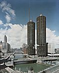
Marina City Towers, 1965
|
Two huge demographic trends—the shift of white Chicagoans to the suburbs and the rise of what scholars call a “spatial mismatch” between job creation on the fringe and the growth of a job-needy population in the core—set the stage for community building after 1950. Led by Mayor Richard J. Daley, postwar civic and
business
figures focused on the drain of tax dollars and attacked the problem through large-scale
planning:
creating
O'Hare airport
and
annexing
it to the city, and clearing “blighted” districts. They also began a tradition of encouraging high-end private developments, from Arthur Rubloff's Carl Sandburg Village to the
condominium
and townhouse complexes on old railroad land near the Loop. These measures, which preserved more vitality in central Chicago than in most old industrial cities, were intertwined with other, more damaging policies. Alarmed by the drain of white population, city officials and private organizations cooperated in reinforcing racial segregation into the 1960s, most notably in building the “second ghetto” of high-rise public housing.
In the last decade of the twentieth century, the second Mayor Daley led yet another wave of elite redevelopment, intended in part to correct the unfortunate consequences of many earlier activities. The hallmark of this effort has been the rapid destruction of most of the high-rise public housing and the promotion of mixed-income communities instead. Like so many previous community developments, this one has been shaped by the continuing pressures of speculation in land, by shifts in the currents of migration, by a tendency to think big, by the vigorous and vocal involvement of local populations, and by intense controversy. And as in so many earlier steps, Chicago is distinctive—taking bigger actions than any other city, attracting national attention, and once again remaking its social landscape.
No single feature of Chicago's social geography is unique: not the flat setting, not the immigrants, not the industry, not the
politics,
not the racial conflict or the urge to plan. It is in
how
and
when
the prominent features of Chicago's development came together, and how they interacted, that the city's distinctiveness lies. Between 1850 and 1930, in a city sprawling as no city ever had, Chicago produced hundreds of new communities, most of them tangled together physically but having clear and strong integrity in the minds of their residents. As the Irish and the Germans and the Italians and Jews moved outward—and, for so very long, the African Americans did not—both the real and the imagined localities exerted a powerful influence on the unfolding and changing meaning of “neighborhood” to the citizens. There has always been more than one Chicago in this location on the lake, and the metropolis that residents celebrate and visitors acclaim today is a product, a synthesis, not only of the many Chicagos of today, but of all those that came before.
Henry C. Binford
|