|
Gallery
|
| The Grid |
| Origins of the Grid |
| The River Breaks the Grid |
| Rationalization of Streets |
| Embracing / Rejecting the Grid |
| Transportation and the Grid |
The city of Chicago embraced the grid set down by government surveyors of the Northwest Territory, with major streets running straight along the section lines. An editorial in the Chicago Tribune of April 29, 1869, noted that "There is no city where the opportunities for straight streets are so advantageous as in Chicago," and recommended where a street was "twisted out of its straight course, interrupted by jogs, or else abruptly stopped by some unimportant cross street" the flaw should be corrected. "Give us straight, broad streets, running uninterruptedly from one extremity of the city to the other, and through the suburbs ad infinitum, if necessary, in the same manner," the editorial continued. This ability to extend the city's grid, ad infinitum, helped in the rapid growth of the city. Plats could be quickly and cheaply drawn, few irregularities needed to be accommodated, and when Chicago annexed adjacent areas, the parts of the jigsaw fit into the whole with little adjustment. Many areas even adopted Chicago's numbering system, so that a traveler passed from city to suburb without a hitch. Not everyone, however, shared the Tribune's enthusiasm for straight and uninterrupted streets. Both inside and outside the city, one can find areas where planners chose to reject the grid in favor of curved streets and cul-de-sacs.
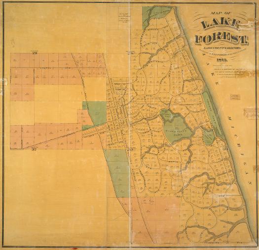
The founders of Lake Forest, a group from the Second Presbyterian Church of Chicago, intended to "establish an institution of learning of a high order in which Christian teaching would hold a central place." For the college and accompanying town, they searched out a site on the city's North Shore, where the Lake Forest Association purchased a wooded area on the lake, broken by ravines. Almerin Hotchkiss, a landscape designer who had previously designed large cemeteries in Brooklyn, St. Louis, and Rock Island, Illinois, laid out the town in 1857. His design for Lake Forest echoes the picturesque style of nineteenth-century cemeteries in the curving streets that converge at the depot of the Chicago and Milwaukee Railroad. On this 1873 map, the underlying grid shows plainly beneath the irregular curved streets; section and subsection lines run north-south and east-west without deviation. On the western portion of the map, the curved streets disappear, and straight streets return.
See also: Lake Forest, IL; Lake Forest College; Landscape Design; Religious Geography; Urbanization on Northwest Side (Map)
Land Subdivision and Urbanization on Chicago's Northwest Side
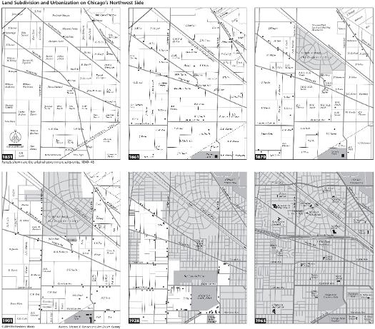
Norwood Park has a dramatic curve that breaks the grid and creates a center for the area. A suburban development created in 1868, Norwood Park was annexed to the city in 1893. This series of maps shows the area's growth in density, with newer developments adopting the more standard straight streets.
See also: Economic Origins of Communities (Map); Annexation; Metropolitan Growth; Norwood Park; Streets and Highways; Subdivisions
Land Sales in Gary, Indiana, n.d.
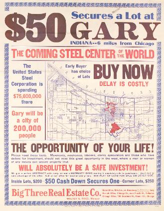
Like Lake Forest, Gary was built by investors with a plan, but in the case of this development in northwestern Indiana, the plan was industrial rather than religious and educational one. The U. S. Steel Corporation developed the core of Gary in conjunction with the steelworks plant. Developers created outlying portions of the city independently. As in Chicago, the added areas fit easily into the existing grid. In this early twentieth-century map, the platted portions in a largely empty landscape conform to the township and section lines envisioned more than a hundred years earlier for the land ordinance of 1785.
See also: Gary, IN; Industrial Pollution; Lake County, IN; Real Estate; Subdivisions
|
The Electronic Encyclopedia of Chicago © 2005 Chicago Historical Society.
The Encyclopedia of Chicago © 2004 The Newberry Library. All Rights Reserved. Portions are copyrighted by other institutions and individuals. Additional information on copyright and permissions. |