
|
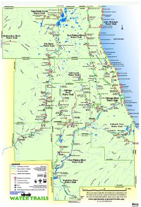
A map prepared by the Openlands Project in 2004 also shows waterways in the Chicago region. In contrast to the 1851 map, which intended to show lands valuable for farming, commerce and industry to potential real estate customers, this map focuses on the region from the perspective of the recreational boater, highlighting water trails for small, nonmotorized boats. The Calumet area of this map (seen above) is particularly unfamiliar because Interstate 94 is not looming along the western edge of Lake Calumet. Over nearly two hundred years, its waterways have been dredged, reshaped, straightened, and dammed as the Calumet became the major harbor for the Chicago region. Recreational boaters have begun to move into water once entirely dominated by lake steamers and ocean-going vessels. Take a virtual trip around the region using the tool bar on the side of the map to see the waterways in other areas. A closer look at this waterways map as a whole reminds us of the many changes which have taken place between the 1851 and today. Waterways supported the region's dramatic growth over the nineteenth and twentieth centuries. Wharves, factories, warehouses, and railroads fronted the rivers of the region. Until the 1920s, untreated sewage from industries and residences poured into these waterways, making most open sewers. Waterways and their banks were places to be avoided until the late twentieth century, when deindustrialization, heightened environmental concern, and changing transportation left waterways cleaner and emptier. Groups like Openlands have encouraged new and innovative ways of thinking about regional waterways. |
||
|
The Electronic Encyclopedia of Chicago © 2005 Chicago Historical Society.
The Encyclopedia of Chicago © 2004 The Newberry Library. All Rights Reserved. Portions are copyrighted by other institutions and individuals. Additional information on copyright and permissions. |
||