With the signing of the 1795 Treaty of Greenville, the United States gained nominal control of a six-square-mile area around the mouth of the Chicago River. Within eight years, the federal government established Fort Dearborn in an effort to exert direct influence within a region populated by Indians, Europeans, Americans, and Métis. The precarious hold that American authorities held in the region could be seen in the destruction of the fort in August 1812. The ultimate victory of American forces in the War of 1812, however, ended the threat of British control in this region. As tax books, election returns, and other official records indicate, during the 1820s and early 1830s an expanding American population began to exert greater economic and political power in the region. While the region had long been part of an international market, the opening of the Erie Canal in 1825 and the advent of steam travel brought the region into much closer connection with the rest of the United States and the wider world market.
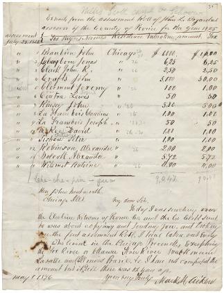
Despite American expansion in the region after 1815, Chicago remained a multi-ethnic place that reflected the global origins of its population. In 1825, tax assessments for residents of the Chicago area appeared in the records for Peoria Country, which had been established that year. Cook County was organized in 1831. The roll of taxpayers from the "Chicago precinct" listed members of several multiracial families that played key roles in the fur trade and other regional economic activities. The Beaubien, LaFramboise, Robinson, and Ouilmette (listed here as Wilemet) families included Métis, Indian, Euro-American, and Euro-Canadian members. Other prominent residents on the list were American Fur Co. officials John Kinzie (Kinsey) and John Crafts, as well as Alexander Wolcott, who worked as a fur trader, physician, and federally appointed Agent of Indian Affairs.
See also: Chicago in the Middle Ground; Cook County; Governing the Metropolis; Metis; Taxation and Finance
Annuities Paid to Potawatomi Chiefs, 1827
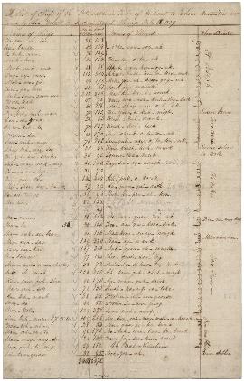
According to treaties signed between independent Native American nations and the United States in the early nineteenth century, the federal government was to make periodic monetary payments (annuities) as partial compensation for the cession of territory. These payments were coordinated by the Agent of Indian Affairs. Alexander Wolcott, Jr., who was a physician and trader in the Chicago area, served as Agent in the Chicago region from the late 1810s through the late 1820s. This document itemized payments made by Wolcott in July 1827 to Potawatomi representatives. The list includes English transliterations of the names of tribal leaders to whom annuities were paid, amounts of those payments, and the name, population, and general location of villages in the surrounding area.
See also: Chicago in the Middle Ground; Potawatomis; Indian Settlement Pattern, c.1830 (Map)
Illinois & Michigan Canal Corridor, 1851
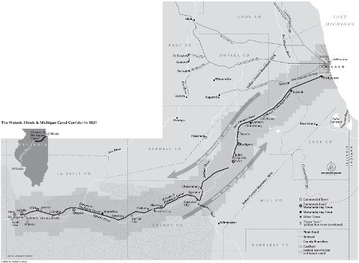
The Illinois and Michigan Canal expanded Chicago's connections to global shipping networks. The opening of the canal in 1848 allowed for goods to be shipped directly to New Orleans via the Illinois and Michigan Canal and Mississippi River system, just as the Erie Canal had made possible direct shipping to New York City via the Great Lakes. Chicago had become an important part of the Atlantic world at a critical juncture between the East Coast and settlement around the western Great Lakes and prairies.
See also: Business of Chicago; Food Processing: Regional and National; Illinois and Michigan Canal; Riverine Systems; Transportation
Plan for Improving the Mouth of the Chicago River, 1830
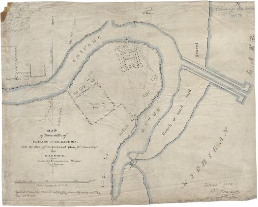
Harbor improvements at Chicago began in the 1820s when soldiers at Fort Dearborn cut a narrow passageway through the sandbar at the river's mouth to enable their small boats to move through to the lake. With the coming of the Illinois and Michigan Canal, the Corps of Engineers formulated plans for improving the river. William Howard mapped the plan seen here in 1830, including the closure of the original river outlet, the excavation of a new district channel into the lake, and the construction of two piers alongside this channel. In 1833, Congress approved $25,000 for improvements which were completed by 1837. These harbor improvements allowed for the expansion of Chicago's involvement in global transportation networks.
See also: Chicago River; Economic Geography; Illinois and Michigan Canal; Loop; Water
|
The Electronic Encyclopedia of Chicago © 2005 Chicago Historical Society.
The Encyclopedia of Chicago © 2004 The Newberry Library. All Rights Reserved. Portions are copyrighted by other institutions and individuals. Additional information on copyright and permissions. |