From the time of Chicago's establishment in 1837 through the 1840s, much of the city's built environment consisted of small, mostly wood building. Even facilities associated with the area's largest infrastructure projects, including the Illinois and Michigan Canal, railroads, and harbor, appeared on the landscape in the form of simple wooden structures. Chicago's physical presence seemed unsophisticated and unimpressive in comparison to world capitals, Eastern cities, and even rival Midwestern cities like St. Louis or Cincinnati. The most imposing structures in the city were grain elevators, which served as hulking symbols of the mercantile activity that dominated the region's economy and connected Chicago to a global market for grain. The wood itself served as a reminder of the significance of lumber trade in the region. By the 1850s and 1860s, some buildings incorporated more elaborate architectural styles that included spires, cupolas, and limestone facades. Despite such ornamentation, the city's built environment remained dominated by the structures (rails, waterways, markets, grain elevators) that sustained its role in global trade.
Map of Chicago and Additions, 1836
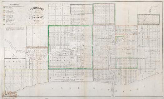
Created by the Illinois and Michigan Canal commissioners and recorded on July 2, 1836, this map mandates that a portion of the lakeshore be dedicated as "Public Ground. A Common to remain forever Open, Clear, & free of any buildings, or other Obstructions Whatever." During the 1830s, land sales and development focused primarily along the Chicago River, which offered shelter from potentially rough lake conditions and thus served as the main point of exchange for commerce flowing in and out of Chicago. Within the coming decades, however, the lakefront also became a focus for commercial development. Note the names of land sections listed in the index in the map's upper-right corner.
See also: Illinois and Michigan Canal; Lake Michigan; Waterfront; Zoning
Bird's Eye View of Chicago, 1857
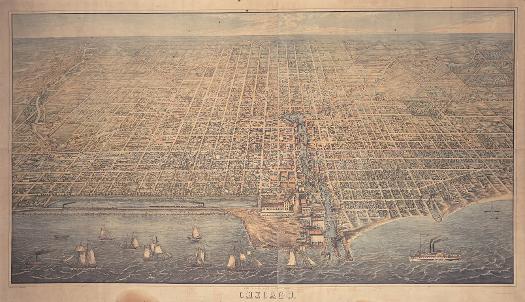
This 1857 lithograph offers astonishing detail of nineteenth-century commercial and civic development in Chicago. One can view such things as the warehouses and heavy traffic along the Chicago River; the haymarket that once stood in the middle of Randolph Street west of the Chicago River (and gave the area the name Haymarket Square); and the 1853 Courthouse (the name for the city hall) bordered by LaSalle, Randolph, Clark, and Washington Streets. Of particular interest in terms of future planning is the absence of what would become Grant Park. Mandates to maintain the lakeshore as public ground were not consistently observed. The Illinois Central Railroad (note the locomotive speeding along the trestle the company constructed as a breakwater in exchange for obtaining this route) and its facilities instead dominate the downtown lakefront.
See also: Chicago River; Grant Park; Metropolitan Growth; Topography; Waterfront
Grain Elevators and Cargo Ships on Chicago River, c.1865
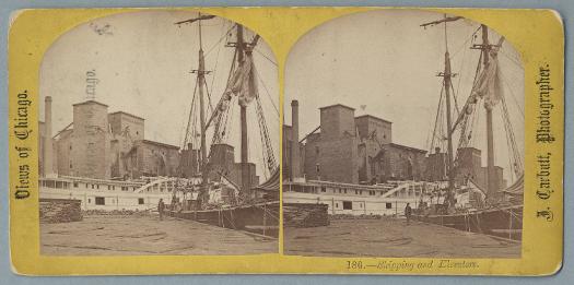
Grain elevators were built near rail stops and barge tie-ups along the Chicago River. Grain shipped into the city was unloaded, weighed, sorted by grade, and loaded into huge overhead bins that combined the produce from farms throughout the Midwest. Chutes then could be opened, allowing grain to flow from the bins into waiting railroad cars and barges, which then shipped the product to customers around the world.
See also: Chicago River; Commodities Markets; Economic Geography; Food Processing: Regional and National; Transportation; Waterfront
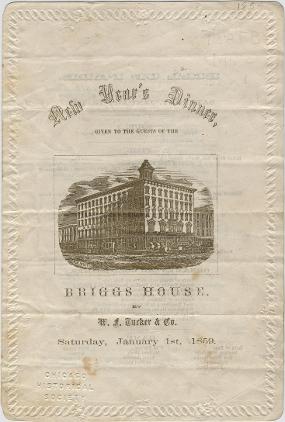
Chicago's role as a mercantile center meant numerous business travelers passing through the city. By the mid-nineteenth century, an increasing number of establishments dedicated to serving that clientele (as well as locals) appeared in downtown Chicago. Located on the northeast corner of Randolph and Wells Streets, the Briggs House hotel and dining room may have served customers with business dealings at the city's Courthouse (just east of the hotel) or perhaps those attending performances at the nearby McVicker's Theater. Most mid-nineteenth-century menus, including this New Year's Day bill of fare from the Briggs House, followed a seventeenth-century French model. Meals began with items like oysters or terrapin soup, before moving on to fish, meat, and finally dessert. Due to the relative popularity of such meals, the city sustained at least three wholesale oyster dealers in 1859.
See also: Entertaining Chicagoans; Hotels; Loop; Restaurants; Globalization (Digital Essay)
|
The Electronic Encyclopedia of Chicago © 2005 Chicago Historical Society.
The Encyclopedia of Chicago © 2004 The Newberry Library. All Rights Reserved. Portions are copyrighted by other institutions and individuals. Additional information on copyright and permissions. |