| Entries |
| S |
|
Suburbs and Cities as Dual Metropolis
|
|
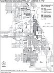
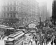
Replete with the starkest of contrasts, the contemporary metropolis—whether measured residentially or occupationally—is indicative of national political structures and an economic system that too often proves disdainful of the inner city, its depleted resources, and its most beleaguered inhabitants. A quandary with deep historical roots, the imbalance intensified during 1980s. Historian Richard C. Wade foresaw as early as 1982 that the Reagan administration's policy—an artifice with the positivist label “new federalism”—deepened imbalances between tax-rich municipalities and their poorest neighbors. Federal spending on cities diminished from 15 to 6 percent of the national budget between 1980 and 1990; the nation's central cities accounted for 43 percent of Americans below the poverty line in 1991, up from 27 percent in 1959. The ratio of median family incomes between metropolitan Chicago's richest and poorest communities in 1989 was nine to one; in 1960, it had been roughly five to one. The United States Conference of Mayors itemized the accumulating urban afflictions in 1986: population loss, impoverishment, racial concentration, deindustrialization, unemployment, homelessness, crime; poor schooling; and high taxes. European urban experts visiting American cities expressed puzzlement upon encountering conditions comparable to those in the Third World.
Historian Kenneth T. Jackson has argued that a single process—population deconcentration—has shaped American metropolitan areas during the twentieth century. (The category of suburban is avoided, wherever possible, because it confuses as much as it explains.) While the foundation of American demographic patterns was constructed in the nineteenth century, in the final third of the twentieth century the process accelerated.
Two fateful statistical benchmarks reached in 1990—both widely reported and assessed—underscored the consequences of sustained deconcentration. First, Chicago's total population fell below 3 million for the first time since 1920; between 1970 and 1990, the city lost 17 percent of its population as its collar-county suburbs advanced 24 percent. Second, Chicago's share of metropolitan private-sector employment dropped to slightly under 40 percent for the first time; it was 56 percent in 1972. In 1992, Sears, Roebuck attracted attention when it relocated corporate headquarters from Sears Tower, affecting five thousand employees. Their destination was a newly constructed, horizontally organized 1.9-million-square-foot facility (as of 2002 expanded to 2.4 million square feet) in the northwestern suburb of Hoffman Estates.
|
Kenilworth, in turn, exemplifies the glitter and aspirations of the dual metropolis. In 1990, it ranked as the wealthiest place in the metropolis (per capita income of $69,814). It was also the nation's ninth richest community and had one of the highest proportions (163 per 10,000 adults) of listings in Who's Who in America; 83 percent of its adult population held at least a bachelor's degree and 98 percent had graduated from high school. Situated in the northeastern corner of Cook County, Kenilworth is one of the eight suburban municipalities known compositely as the North Shore, all linked to Chicago by a railroad operating since 1855. The rush-hour commute by rail covers 16 miles in 32 minutes. Such places—whether on Philadelphia's Main Line or north of New York City in Westchester County—amounted to classic suburbs. Cultural homogeneity reinforced by restrictive covenants —white Protestants only—defined what Kenilworth's founder envisioned. Contrived as a sociological island, it was purposefully designed to resist the sweeping social and cultural changes unleashed by the economic transformation of the nineteenth century. By 1990, only 60 of Kenilworth's 2,562 residents were nonwhite. The median housing price exceeded $500,000.
|
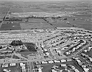
Naperville, 30 miles west of Chicago, is a widely cited example of population deconcentration in large American metropolises. As recently as 1950 it looked like a commuter suburb and stood 91st among Illinois municipalities in total population. Today its characteristics defy traditional assumptions about urban and suburban. Labels for such places include boomburb, edge city, technoburb, and totalized suburb. These communities are situated 30 to 40 miles from their original urban centers. People work, live, and pursue many of their leisure activities in some 200 of these settings scattered across the United States (e.g., Bellevue, Washington; Gwinnett County, Georgia; Overland Park, Kansas; and Tysons Corner, Virginia).
Notable within the dual metropolis for its combination of burgeoning population and affluence, Naperville was singled out in 1992 as having the lowest poverty rate (1.5 percent) among cities nationwide with populations of at least 50,000. Whatever label is attached to this locale, its rudimentary ingredients included location along interstate highways, ease of access to major airports, reliance upon automobiles, excellent public schools, university research centers in close reach, and rapid economic development led by assorted technology-related and retail enterprises. Naperville's corporate roster includes BP Amoco Research Center, Dow Jones & Co., Lucent Technologies, Nalco Chemical Company, and Nicor. Nearby are Argonne National Laboratory and Fermi National Laboratory.
Naperville ranked fourth in population (ahead of Peoria and behind Aurora) statewide in 2000. It is the largest city in DuPage County (and its oldest, founded in 1831), with a population of 128,358 in 2000 (its municipal bounds have spilled over into Will County). It experienced the second biggest surge (growing by 43,007, or 50 percent) among the 20 largest municipalities within the collar counties over the preceding decade; surpassing 100,000 in 1994, it was the 10th-fastest-growing city in the nation since 1990. In new-home construction it ranked first among the collar counties as of 1982; in physical size, it expanded from 5.8 square miles in 1960 to 31 square miles, the result of nearly 400 separate annexations. But in its demographic attributes, unlike so many places conventionally portrayed as suburbs, Naperville changed notably. Among its 5,272 residents in 1940, 99.9 percent were white. In 2000, nonwhites accounted for 15 percent of its total population. Asians constituted the largest nonwhite proportion (9.6 percent), while African Americans accounted for 3 percent of the population.
Metropolitan Chicago's deconcentration is hardly a contemporary phenomenon. From 1860 to 1910, the city's population increased 20 times, to nearly 2.2 million; New York City's, by contrast, grew sixfold. By 1910, Chicago's population exceeded Berlin's (2 million) and was making inroads upon Paris (2.9 million). Although Chicago's physical size had expanded significantly between 1880 and 1900, from 43 to 169 square miles, as a result of consolidation and annexation, thereafter its growth stagnated. Suburbs—among them Evanston and Oak Park—rejected annexation during the 1890s. Their residents demonstrated a determination to set apart their communities politically and culturally.
|
|
|

|
But the deconcentration of Chicago's population, as the authors of the Plan of Chicago recognized, could not be denied. Between 1900 and 1910, the population of the city and the six-county region increased nearly 30 percent. Lake County, Illinois, was the fastest-growing county in the metropolis; its population increased 60 percent to Cook's 31 percent. During the following decade the population of Chicago increased 24 percent, but the average growth of the combined northern and western suburbs was 100 percent. Significant advances in population registered in Winnetka (113 percent), Oak Park (105 percent), Wilmette (58 percent), and Evanston (49 percent). Starting in the mid-1920s, major corporations offering well-paid employment departed from Chicago—including Abbott Laboratories (to North Chicago ), G. D. Searle ( Skokie ), Jewel Tea Company ( Barrington ), Motorola ( Franklin Park )—to fulfill their needs for enlarged operating expanses.
A 1947 census bureau study of the redistribution of population within American metropolises pinpointed a multiplicity of causal factors: improved mass transit; the cachet of a suburban address; the deconcentration of industry; and technological advances such as telephone and electrical services. But the primary cause—“a factor of great importance,” claimed Thompson—was the automobile. The marriage between suburb and automobile was consummated during the 1920s: vehicle registration nationwide reached 8 million in 1920 and 26 million by 1929.
|
|
|
At the beginning of the twenty-first century, meaningful prospects existed for addressing Chicago's metropolitan future. They centered in an abiding faith in our capacity as a democratic nation to foster renewal and change, with the suburban majority discovering compelling reasons to recast its sensibilities on a regional scale. One project took aim at alleviating the spatial mismatch. Originally advanced by the mayor of Schaumburg in 1997 and endorsed by other municipalities along the northwest suburban corridor, it anticipated shortages in the private-sector workforce. This unprecedented plan would expand the reach of the Chicago Transit Authority rail line into the northwest suburbs, with suburban stations strategically situated at Hoffman Estates and Woodfield Mall. The CTA outlined a more comprehensive design in 2002 to extend itself beyond the city in other directions as well.

|
But disagreement surfaced about how to implement policy objectives. Activists—urban and suburban—envisioned political action and welcomed the likelihood of needier communities contesting for the prerequisites savored by their prosperous neighbors. Whether by means of consensus or contention, the desired end might culminate in a series of political and economic imperatives—involving the public and private sectors, diverse neighborhoods and communities, giant corporations, small enterprises, and labor unions—at the local, state, and even national levels.
Legal scholar Gerald E. Frug has raised the possibilities of interlocal political institutions. The Puget Sound Regional Council, founded in 1991 to encompass four counties constituting metropolitan Seattle, is a singular example. Constituencies, in addition to the 4 counties, include 70 municipalities, 3 public authorities, and 2 state agencies. The problems it contends with—in the areas of transportation, economics, and growth management—are caused mainly by population deconcentration. In other metropolises, initiatives take varied forms, among them Minnesota's Fiscal Disparities Act (1971), Oregon's Urban Growth Boundaries (1973), the South Coast Air Quality Management District in Southern California (1976), and the Georgia Regional Transportation Authority (1999). Chicago's programmatic strategy, embodied in Metropolis 2020, is by contrast decidedly ad hoc.
“Metropolitan” is a contested word in the glossary of American urban history, a continuous source of fractious debate. Reaching back to the very inception of the American nation-state, the lack of provision for cities in the federal system created by the Constitution has rendered their status perpetually unresolved. Viewed through skeptical eyes, “metropolitan” is regarded pejoratively, invoking images of people furtively escaping into their local suburban enclaves. Their expectation: eluding the intricacies associated with their daily lives as citizens of the metropolis. Alternately, this key word also can take its form as a set of programmatic solutions. Their goal: diminishing rather than perpetuating the disparities between the neighborhoods and communities that separate the citizens who inhabit the dual metropolis.
The Encyclopedia of Chicago © 2004 The Newberry Library. All Rights Reserved. Portions are copyrighted by other institutions and individuals. Additional information on copyright and permissions.